
Covid 19 pandemic is spreading like fire in India, showing no sign of slowness. It a big to stop the rapid spread of Coronavirus in India, the central government has introduced a new vaccine registration portal – Cowin.
If you are above 18 years of age, you can receive the vaccination. It’s recommended to get the vaccination as soon as possible. Along with the vaccination, WHO and CDC have recommended avoiding mass gatherings, close contacts, wearing a mask, use of a hand sanitizer.
Now that Covid 19 shows no sign of slowness, several tech companies have taken steps to make people aware of the local & global circumstances.
Google Maps now offers data related to the pandemic. Through Google Maps, you can get information about the number of Covid patients.
Steps to View COVID-19 Data in Google Maps
So, whether you want to get information about your hometown, somewhere your family lives, or a place you are planning to visit, open the Google Maps website to check the number of new cases.
Along with the new Covid cases, Google Maps also shows you confirmed cases and few other details. So, in this article, we will share a detailed guide on how to view Covid-19 data around the world in Google Maps. Let’s check out.
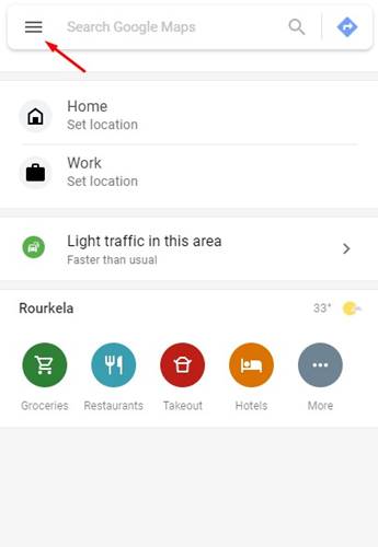
Step 1. First of all, open the Google Maps website on your PC. You can use any web browser to open Google Maps.
Step 2. On Google Maps, click on the ‘Menu‘ icon as shown in the screenshot below.
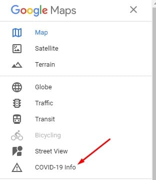
Step 3. On the left pane, click on the ‘Covid-19 info’ option.
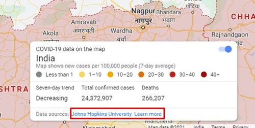
Step 4. The map will list your current location along with the total confirmed Covid Cases. It will also show the Seven-day trend if available. Along with that, Google Maps also shows you the number of deaths in the location.
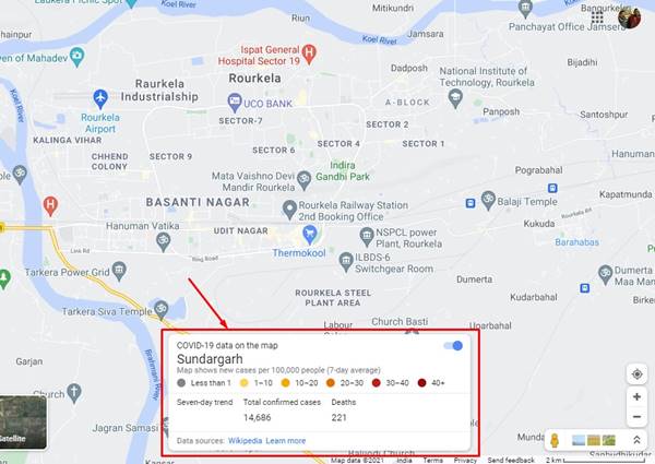
Step 5. The Covid 19 dialog box will remain open as you move around the map, making it easy to gather the data. You can zoom in and zoom out of Google Maps using the mouse scroll wheel.

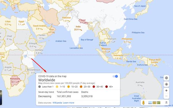
Step 6. You can drag and drop the Maps to change the location. If you zoom out as far as the tool lets you, you will see the worldwide data.
Step 7. Google Maps Covid-19 data panel also shows you the data sources. You can click on the data sources to gather more details.
That’s it! You are done. This is how you can view COVID-19 data worldwide in Google Maps.
If you are eligible for Covid vaccination, but not yet applied for it, then please check this article – Register On CoWIN Portal for Covid-19 Vaccination.
So, this article is all about how to view Covid-19 data around the world in Google Maps. I hope this article helped you! Please share it with your friends also. If you have any doubts about this, let us know in the comment box below.
")

