Indians Will be proud of it and the reason – ISRO is going to launch Indian Regional Navigation Satellite System (IRNSS) the more powerful and accurate.
The ISRO is going to launch Indian Regional Navigation Satellite System (IRNSS) the more powerful and accurate Navigational system than American Global Positioning System (GPS). India is moving towards in more advanced technology, the senior scientist from ISRO has explained how the process of IRNSS can visualise more accurate than the American GPS system.
The desi navigation system from Indian scientist makes major changes in all technology and gadgets, all the developers and manufacturers will have to also manufacture and reproduce Indian own navigation program in the devices.

Also Read: How to Wipe System Cache Partition In Android
Bangalore: On Thursday ISRO major meeting with leading organisations including, location and navigation device manufacturers, Technology Developers, Global Information System and Mobile Phone Manufacturers. ISRO in the meeting demonstrates that how the new IRNSS will work more advanced than the traditional American GPS Also presented that what are the advantages of using IRNSS.
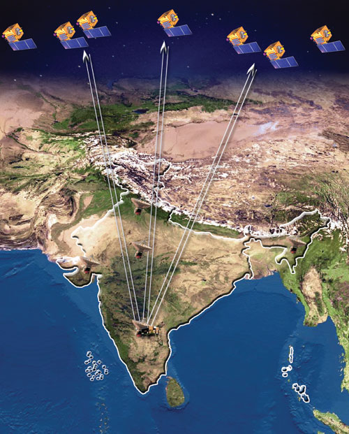
ISRO also demonstrated how the seven constellation satellite will work together once operational by July 2016, he all seven satellite will bring more accurate navigation experience than American GPS system, however, the overall meeting will be representing the IRNSS that how it will work with more accuracy the visual experience in Land street mode. The senior scientists from Space Application Centre (SAC) – Ahmedabad also attended the meeting in Bangalore.
Also Read: Top 10 Best Operating Systems For Hackers
ISRO said that the new IRNSS will be integrated with all new devices as well as it will have its own device for public like Cars navigational system. The unrelated device from American GPS, ISRO to delivered its own additional hardware in handheld devices that will be connected with IRNSS satellites to receive S-Band signals and L-Band signals from phone software to interconnect.
The connection between S and L-Brand and signals will always be in connection with all IRNSS satellite which receiving and sending data to satellite constellation of the IRNSS navigation system, the system software from Satellite itself reconcile the unfortunate errors caused by atmospheric disturbances significantly. The senior ISRO official told that it will give superior quality in providing location than the American GPS system.
Also Read: How To Recover Data From Crashed Operating System
The ISRO officials said that all the seven satellites of Indian Regional Navigation Satellite System as IRNSS will be plotted in orbit expected by March 2016. ISRO also said that this signals are not only available in India or its neighbouring countries but also across the entire globe.
ISRO is performing better from the year of 2010, since then, the development project in IRNSS have taken higher pickups, the new IRNSS initiative from ISRO to present the world the more accurate navigation system, this IRNSS has set to become the first independent satellite navigation system – to provide accurate navigation experience to its Indian region users in all the platform such as position, velocity and time. the system has integrated a constellation of seven satellite with a vast number of connection and networks on the ground level systems.
Also Read: How to Detect Keylogger In System
In March 2015, ISRO has launched IRNSS-1D with embed navigation system and the launch was successfully reached to space, it has been confirmed the satellite meets all the necessary requirement to become independent positioning system which operates other six satellites.


